


Need help?
Talk to trip expertExplore the Manaslu region with our updated, high-quality Manaslu Trek Map, designed to guide trekkers along one of Nepal’s most scenic and remote Himalayan routes. This map is perfect for those who want to navigate trails with confidence, understand the terrain, and discover hidden gems along the way. Whether you are trekking the Manaslu Circuit, Manaslu with Tsum Valley, or the Lower Manaslu Trek, this map provides clear, precise, and practical guidance for every stage of the journey.
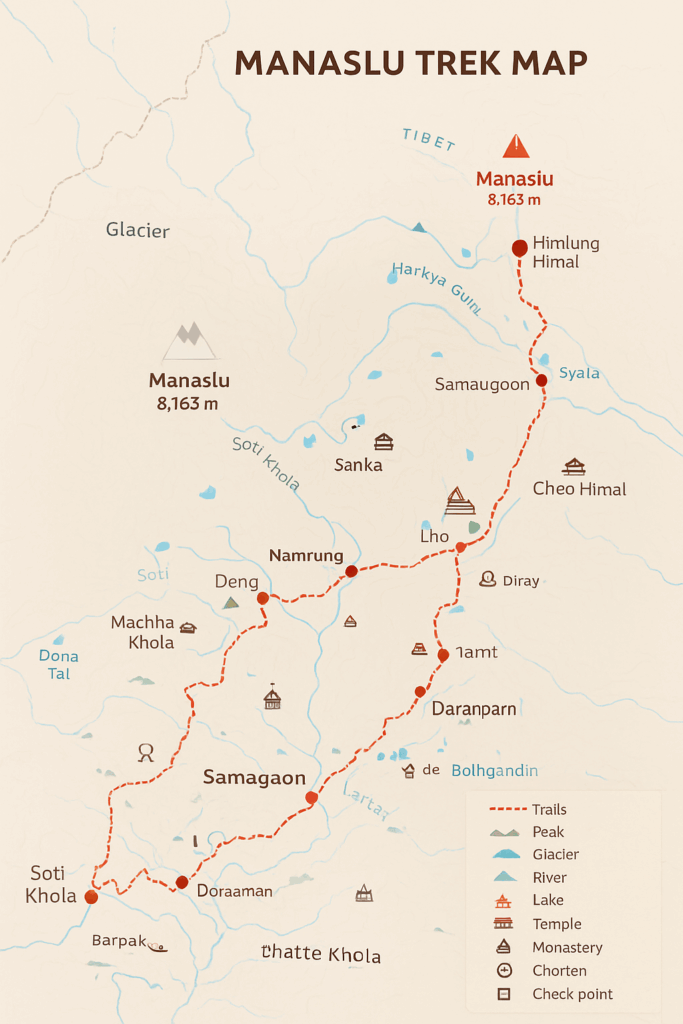
Digital Map Features & Visual Tools
Our Manaslu Trek Map incorporates all key geographical and cultural features using standardised icons and clear colour codes:
Trails & Routes:
Red dashed lines: Main trekking routes
Yellow or green dashed lines: Secondary paths and side trails
Peaks: Marked with triangular symbols and elevation
Glaciers & Rivers: Blue shaded paths with labels for major glaciers (e.g., Larkya, Syala)
Lakes & Tals: Circles in varying shades of blue (e.g., Birendra Lake, Kalchuman Tal, Dona Tal)
Religious & Cultural Sites: Temples, monasteries, chortens, and mani walls
Settlements & Checkpoints: Villages and teahouses marked with H or square icons
Conservation Areas & National Parks: Green-bordered zones highlighting protected regions
International & Regional Boundaries: Pink borders mark the international boundary; conservation zones are highlighted in green
The map is interactive, allowing you to zoom in and out easily using the plus and minus buttons, and scroll to explore valleys, ridges, and passes in detail.
Trail Descriptions Based on Map Highlights
Access & Starting Points
Soti Khola: The gateway to the Manaslu region. From here, the main trekking trail follows the Budhi Gandaki River.
Machha Khola: A small riverside village; the trail begins in forested valleys with suspension bridges and terraced fields.
Jagat: The first checkpoint village, with stone houses and traditional farmland.
Key Villages & Cultural Spots
Deng: Dense forests and alpine vegetation; the trail gradually gains altitude here.
Namrung: Monasteries, prayer walls, and panoramic mountain views.
Lho: Cultural hub with Ribung Monastery and Tibetan-influenced architecture.
Samagaon: Base for acclimatisation and spiritual exploration; close to Mt. Manaslu’s impressive peak.
Samdo: Last permanent settlement before the high pass, showcasing Tibetan trade and mountain lifestyle.
High Passes & Alpine Terrain
Dharamsala (Larkya Phedi): High-altitude resting point before Larkya La Pass.
Larkya La Pass (5,160 m): Highlighted with peak icons and elevation labels; main crossing point connecting the valleys.
Bimthang: Alpine meadows, surrounded by snow-capped peaks, marked clearly for orientation.
Side Trails & Optional Routes
Manaslu Base Camp: Side trail marked in yellow; optional for trekkers seeking a closer view of the 8,163 m peak.
Tsum Valley: Northern branch highlighted with dotted lines; includes Chumling, Chhokangparo, and Mu Gompa.
Lower Manaslu Trail: Southern approach through Barpak, Laprak, and Tatopani; scenic and culturally immersive.
Navigation & Practical Use
The main trekking route is marked in red, making it easy to follow from Soti Khola to Dharapani.
Villages and campsites are clearly indicated, ensuring trekkers know where to rest each night.
Glaciers, rivers, and lakes are labelled for orientation and optional exploration.
Religious and cultural landmarks are represented with icons for monasteries, temples, and mani walls, allowing trekkers to plan cultural stops.
The map scale is 1:300,000, meaning one inch represents 300,000 inches of actual terrain, providing both overview and local detail.
Why This Map is Optimised for Trekkers
Reduced trek difficulty: The trail markings follow the most gradual and safe routes, avoiding overly steep or risky paths whenever possible.
High success rate: Clear altitude progression and rest points are integrated, helping trekkers acclimatise effectively.
Ease of use: Zoom functionality, icons, and clear labelling make navigation intuitive even in remote valleys.
Comprehensive coverage: Combines Manaslu Circuit, Tsum Valley, and Lower Manaslu trails into one resource.
Scenic and cultural insight: Mark’s monasteries, villages, lakes, and other highlights to enhance your trekking experience.
Important Map Notes
Restricted Areas: Manaslu is a restricted area; marked boundaries help trekkers remain compliant.
Conservation Zones: Green zones indicate national parks and conservation areas.
Glacial Hazards: Major glaciers are highlighted for orientation and safety.
Altitude Awareness: High points like Larkya La Pass are clearly marked with elevation icons to help plan rest and acclimatisation.
Why This Manaslu Trek Map is Unique and Trekker-Friendly
Our Manaslu Trek Map stands out from standard trekking maps because it is specifically designed with trekkers in mind, combining precision, practicality, and cultural insight in one interactive digital tool. Here’s why it’s the ideal companion for your Himalayan adventure:
Trekkers-Focused Design
Intuitive Trail Markings: Main routes, side trails, and alternative paths are clearly differentiated with red, yellow, and green lines, ensuring you can plan according to your pace and experience level.
Altitude and Acclimatisation Awareness: High points like Larkya La Pass (5,160 m) and Dharamsala are clearly marked, with elevation labels to help manage acclimatisation and avoid altitude sickness.
Rest & Stay Guidance: Villages, teahouses, and campsite locations are prominently marked, allowing trekkers to plan overnight stops efficiently.
Interactive & Practical Features
Zoomable interface and scroll functionality help you examine valleys, ridges, and passes in detail.
Standardised icons make it easy to identify cultural sites, monasteries, rivers, glaciers, and alpine lakes.
Conservation zones and restricted areas are clearly outlined, keeping trekkers compliant and safe.
Scenic, Cultural, and Hidden Gems Highlighted
This map is more than just a navigation tool; it is a visual journey of the Manaslu region, pointing out spots you won’t want to miss:
Samagaon: The spiritual heart of the trek, with panoramic views of Mt. Manaslu and nearby monasteries.
Tsum Valley: Off-the-beaten-path area rich in Tibetan culture, traditional villages, and sacred monasteries.
Bimthang: Stunning alpine meadows surrounded by towering snow-capped peaks.
Manaslu Base Camp: Perfect for trekkers seeking close-up views of the 8,163 m peak.
Lower Manaslu Trail: Offers scenic trekking through Barpak, Laprak, and Tatopani, combining natural beauty and cultural immersion.
Safety & Confidence
Clear depiction of glaciers, rivers, and high-altitude passes reduces the risk of getting lost in remote areas.
Shows the safest, most gradual trekking routes while providing alternative paths for experienced adventurers.
Conservation zones, restricted boundaries, and glacial hazards are highlighted to enhance planning and safety.
Why Trekkers Love It
All-in-One Resource: Covers Manaslu Circuit, Tsum Valley, and Lower Manaslu trails in a single, easy-to-use map.
User-Friendly Navigation: Even first-time trekkers can easily follow trails and explore hidden spots without confusion.
Cultural Enrichment: Marks monasteries, chortens, mani walls, and traditional villages to enhance your Himalayan experience.
Optimised for Success: Helps trekkers plan rest stops, acclimatisation days, and scenic detours efficiently, increasing the chance of completing the trek safely and comfortably.
In Short:
This map is more than a navigation tool—it’s a trekker’s companion, blending safety, adventure, culture, and scenic beauty. From high passes and glaciers to hidden valleys and sacred monasteries, every feature is curated to give you the ultimate Manaslu trekking experience with confidence, clarity, and inspiration.
Conclusion
This updated Manaslu Trek Map is a complete, practical, and highly detailed digital guide for all trekking enthusiasts. Whether exploring the remote circuits, Tsum Valley, or the Lower Manaslu route, this map provides everything you need to navigate safely, enjoy the scenery, and maximize your trekking success.
It combines cultural landmarks, high-altitude passes, alpine lakes, glaciers, villages, and main trails in one interactive tool, giving trekkers confidence, clarity, and a unique Himalayan experience.